There are not many users that really know the advanced tools available on Google Maps: one of them allows you to measure distances from one point to another in the world. Measuring distances does not mean knowing how many kilometers of the road there are from one place to another, but how many kilometers pass, as the bird flies, from one point to any other; a straight line will then be drawn from one point to the other. In this guide, I will try to teach you how to measure distance on Google Maps below.
Steps to Measure Distance on Google Maps (2023)
In the following guide, I will show you how to calculate distance on Google Maps using the virtual ruler on the website or within the Google Maps apps, so you always know how many meters or kilometers pass between any two points on the map.
Given the simplicity of this function, we will show you how to use it both on the website (using a browser like Google Chrome) and how to measure the distance between points from the Google Maps app, which we remind you is available for Android and for iPhone/iPad.
Measure Distance on Google Maps from the PC
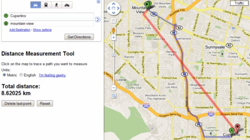
- If you want to measure a distance from any computer, open the Google Maps site first.
- Click with the right mouse button on the point from which you want to start the measurement.
- Select the Measure distance option to fix the first measurement point.
- Go to the end-point and press right-click again and this time select the item Distance up to here to start the measurement with the “virtual ruler”.
- The measurement of the distance between the two points will appear in a straight line.
- Pressing the right button again we can use the Delete measurement item to reset the virtual ruler and carry out a new measurement between two different points of the globe.
Alternatively, we can add the intermediate stages of the measurement by starting a measurement and pressing the left button on the map, so as to be able to perform a distance calculation based on several different points.
Measure Distance on Google Maps from Android and iPhone/iPad
- If you want to measure a distance on Google Maps for Android and for iPhone/iPad, first open the Google Maps app on your mobile device.
- Touch and hold on to any point on the map to make a red placeholder appear.
- Touch at the bottom on the name of the place and, in the screen that opens, scroll down and press the Measure distance item.
- Now, all we have to do is drag the map and form the ruler to the desired destination point, so as to obtain the measurement in meters or kilometers.
- To add other points to the measurement, simply press the + icon at the bottom right, so as to lock the intermediate point and continue the measurement by dragging the map to the next point.
- To cancel the measurement carried out up to that moment, all we have to do is press the back button of the phone or swipe from the edge of the screen, so that we return to the normal map view.
That is all you need to know about how to measure distance on Google Maps. While you are here, you might be also interested to know How to Turn Off Dark Mode on Google, and How to Drop a Pin in Google Maps.